Temperature & Pressure
Temperature & Dew Point
Temperature & Radar
Wind Speed & Pressure
Wind Gusts & Pressure
Relative Humidity
Potential Temperature & Radar
Eq. Pot. Temperature & Radar
LCL & Radar
Divergence & Pressure Change
"Feels Like" Temperature
Camera Map & Radar
Significant Weather Summary
Severe Weather Summary
Winter Weather Summary
Station Snow Summary
Estimated Snow Depth
1 Hour Snow Depth Change
1 Hour Precipitation
24 Hour Precipitation
Incoming Solar Radiation
24 Hour Site Extremes
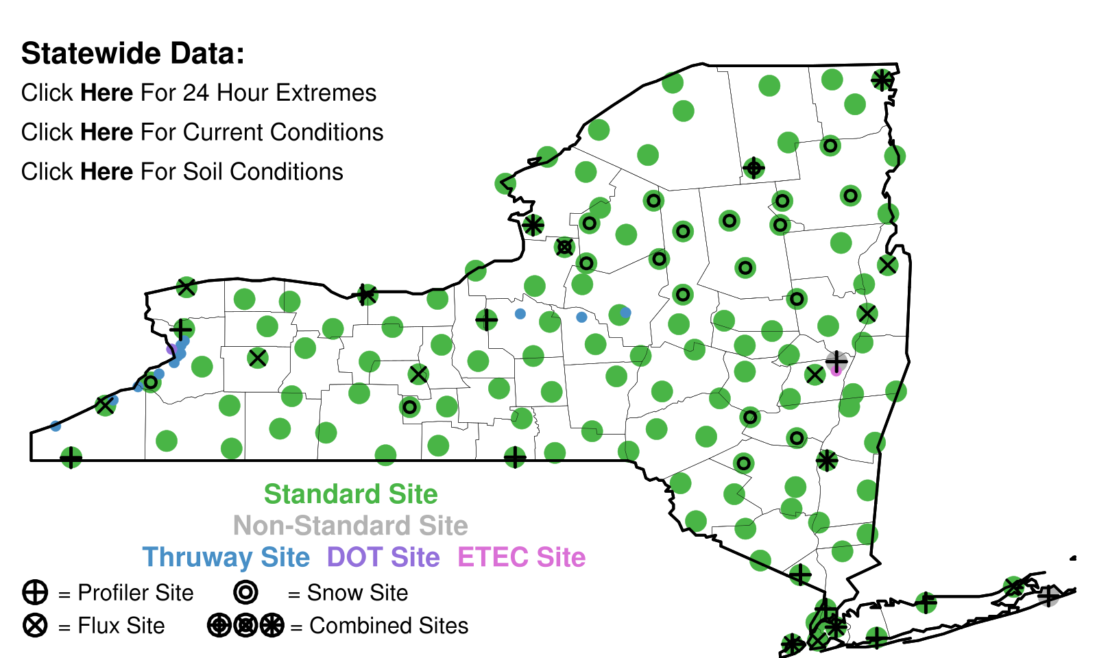
Current Radar & Observations
Current Observations [python]
Current Observations
*Maps Update Every 5 Minutes
Temperature & Pressure
Temperature & Dew Point
Wind Speed & Pressure
Wind Gusts & Pressure
Relative Humidity
Potential Temperature & Radar
Eq. Pot. Temperature & Radar
LCL & Radar
Divergence & Pressure Change
"Feels Like" Temperature
Camera Map & Radar
Severe Weather Summary
Winter Weather Summary
Estimated Snow Depth
1 Hour Snow Depth Change
1 Hour Precipitation
Incoming Solar Radiation
Observations & Radar
*Loops Update Every 5 Minutes
Moisture Percentile:
5 cm
25 cm
50 cm
5-50 cm
Moisture Percentile Loop:
5 cm
25 cm
50 cm
5-50 cm
24 Hour Moisture Percentile Change:
5 cm
5-50 cm
Temperature Percentile:
5 cm
25 cm
50 cm
5-50 cm
Temp. Percentile Loop:
5 cm
25 cm
50 cm
5-50 cm
24 Hour Temperature Percentile Change:
5 cm
5-50 cm
*Above Maps Update Each Hour, Others Every 5 Minutes
Fire Weather:
Four Fire Factors
Complex Fire Factors
Fire Wx Loop:
Four Fire Factors
Complex Fire Factors
All-In-One-Maps:
Current Soil Data
24 Hour Change
Estimated Surface Temperature
Flux Site Temperatures
Maximum Temperature:
1 day
2 day
3 day
5 day
7 day
Minimum Temperature:
1 day
2 day
3 day
5 day
7 day
Maximum Heat Index:
1 day
2 day
3 day
5 day
7 day
Minimum Wind Chill:
1 day
2 day
3 day
5 day
7 day
Maximum Wind Gust:
1 day
2 day
3 day
5 day
7 day
Maximum Sea-Level Pres:
1 day
2 day
3 day
5 day
7 day
Minimum Sea-Level Pres:
1 day
2 day
3 day
5 day
7 day
Maximum Dew Point:
1 day
2 day
3 day
5 day
7 day
Minimum Rel. Humidity:
1 day
2 day
3 day
5 day
7 day
Total Precipitation:
1 day
2 day
3 day
5 day
7 day
Total Estimated Snowfall:
1 day
2 day
3 day
5 day
7 day
*Maps Update Daily Around 07 UTC
Jump To Archive
Mean Temperature:
1 day
7 days
30 days
90 days
Mean Temp Anomaly:
1 day
7 days
30 days
90 days
Mean High Temperature:
1 day
7 days
30 days
90 days
Mean High Anomaly:
1 day
7 days
30 days
90 days
Mean Low Temperature:
1 day
7 days
30 days
90 days
Mean Low Anomaly:
1 day
7 days
30 days
90 days
Cooling Degree Days:
1 day
7 days
30 days
90 days
Heating Degree Days:
1 day
7 days
30 days
90 days
Precipitation Total:
1 day
7 days
30 days
90 days
Precipitation Anomaly:
1 day
7 days
30 days
90 days
Mean Solar Insolation:
1 day
7 days
30 days
90 days
Miscellaneous:
1 Day:
σ Tmax
σ Tmin
90 Day:
Tmax
Tmin
*Maps Update Daily Around 830 UTC
Jump To Archive
Temperature Records:
High Temperature
Low Temperature
Coldest High
Warmest Low
Max Diurnal Range
Min Diurnal Range
Max 24 Hour Drop
Max 24 H Rise
Max 3 H Drop
Max 3 H Rise
Max 1 H Drop
Max 1 H Rise
Max 15 Minute Drop
Max 15 M Rise
Max 5 M Drop
Max 5 M Rise
Max Daily Change
Min Daily Change
Max Inversion
Max Lapse Rate
Max 9 m Temp
Min 9 m Temp
Wind:
Max Sonic Wind
Sonic Gust
Prop Wind
Prop Gust
Calmest Day
Windiest Day
Gustiest Day
Daily Damage
Precipitation:
Daily Precipitation
24 Hour Precip
3 H Precip
1 H Precip
15 Minute Precip
5 M Precip
< 32F 1 H Precip
Pressure:
Max SLP
Min SLP
Max 3 H Drop
Max 3 H Rise
Max 1 H Drop
Max 1 H Rise
Max 15 M Drop
Max 15 M Rise
Moisture:
Max Dew Point
Min Dew Point
Min Rel. Hum.
Solar:
Max Daily Insolation
Max 5 Minute Irradiance
Feels Like:
Max Heat Index
Min Wind Chill
Warmest Daily Min Heat Index
Coldest Daily Max Wind Chill
Soil:
Max 5 cm Temp
Min 5 cm Temp
Max 25 cm Temp
Min 25 cm Temp
Max 50 cm Temp
Min 50 cm Temp
Max 5 cm Moisture
Min 5 cm Moisture
Max 25 cm Moisture
Min 25 cm Moisture
Max 50 cm Moisture
Min 50 cm Moisture
Max Total Column Moisture
Min Total Column Moisture
Miscellaneous:
Max Daily Avg Snow Depth
Highest LCL
Max Inversion
Max Lapse Rate
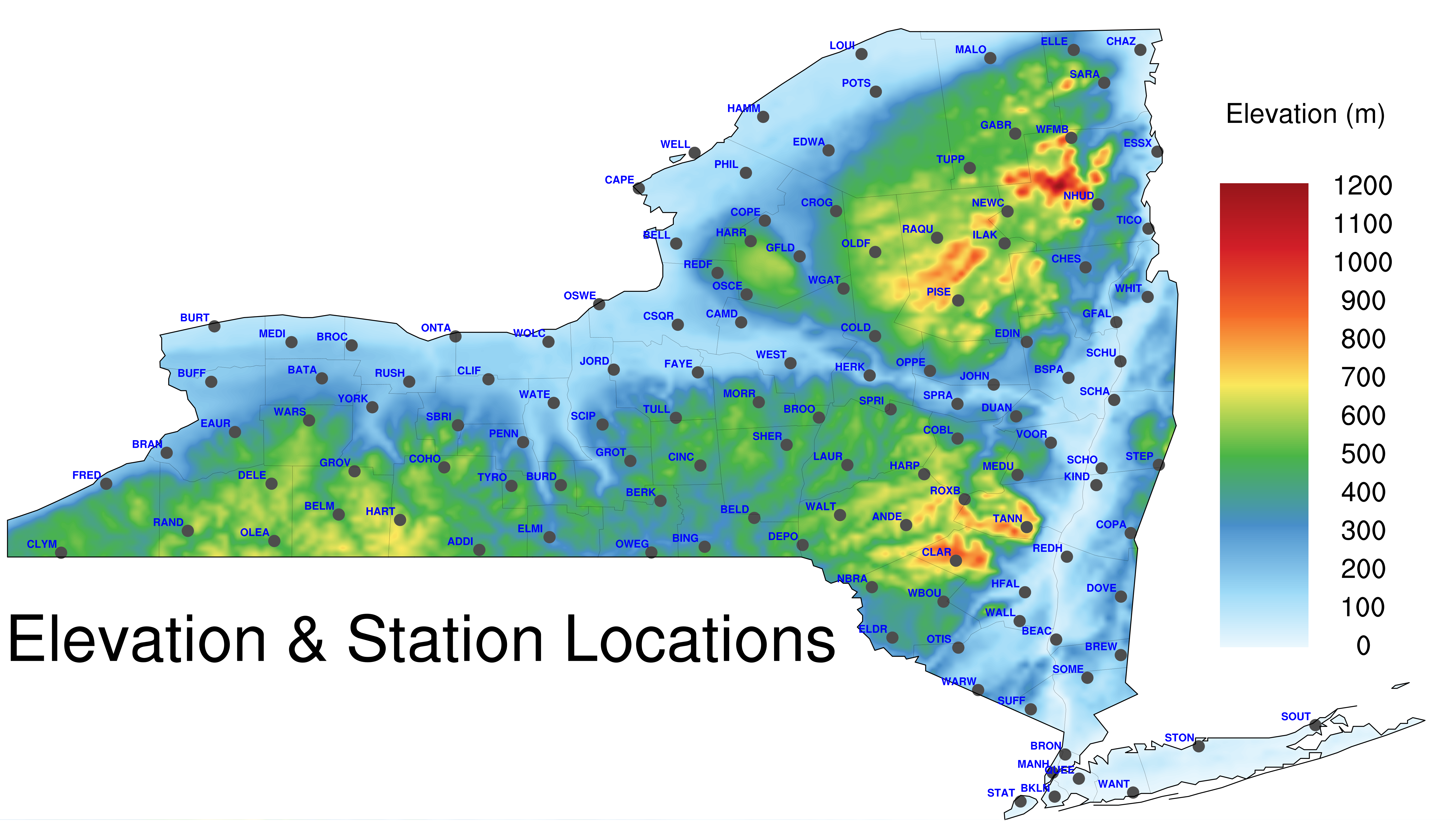
Elevation
Days In Record
*Maps Update Daily Around 930 UTC
Maximum Hourly Fields:
Temperature
Surface T
Heat Index
Wind Gust
Dew Point
Relative Humidity
Max 1H Reflectivity
Visibility
Ceiling
Shortwave Down
Latent Flux
Sensible Flux
Surface-Based:
CAPE
CIN
90 mb Mixed Layer:
CAPE
CIN
Integrated Graupel
2-5 km Updraft Helicity
Lightning
Hail
Hourly:
Precip
F'zing Rain
Sleet
Wet Snow
Snow LE
Snow
Total:
Precip
F'zing Rain
Sleet
Wet Snow
Snow LE
Snow
Mean Hourly Fields:
Temperature
Surface T
Heat Index
Wind Gust
Dew Point
Relative Humidity
Max 1H Reflectivity
Visibility
Ceiling
Shortwave Down
Latent Flux
Sensible Flux
Surface-Based:
CAPE
CIN
90 mb Mixed Layer:
CAPE
CIN
Integrated Column Graupel
2-5 km Updraft Helicity
Lightning
Hourly:
Precip
F'zing Rain
Sleet
Wet Snow
Snow LE
Snow
Total:
Precip
F'zing Rain
Sleet
Wet Snow
Snow LE
Snow
Median Hourly Fields:
Temperature
Surface T
Heat Index
Wind Gust
Dew Point
Relative Humidity
Max 1H Reflectivity
Visibility
Ceiling
Shortwave Down
Latent Flux
Sensible Flux
Surface-Based:
CAPE
CIN
90 mb Mixed Layer:
CAPE
CIN
Integrated Column Graupel
2-5 km Updraft Helicity
Lightning
Hourly:
Precip
F'zing Rain
Sleet
Wet Snow
Snow LE
Snow
Total:
Precip
F'zing Rain
Sleet
Wet Snow
Snow LE
Snow
Minimum Hourly Fields:
Temperature
Surface T
Heat Index
Wind Gust
Dew Point
Relative Humidity
Max 1H Reflectivity
Visibility
Ceiling
Shortwave Down
Latent Flux
Sensible Flux
Surface-Based:
CAPE
CIN
90 mb Mixed Layer:
CAPE
CIN
Hourly:
Precip
F'zing Rain
Sleet
Wet Snow
Snow LE
Snow
Total:
Precip
F'zing Rain
Sleet
Wet Snow
Snow LE
Snow
*Forecasts Are Made Hourly From A Time-Lagged Ensemble
RFC Flash Flood Guidance:
1 hour
3 h
6 h
12 h
24 h
*1 h, 3 h, & 6 h Maps Update Around 10 Minutes After The Hour
MRMS Precip. (Radar):
1 h
3 h
6 h
12 h
24 h
48 h
72 h
*Hourly Maps Update Around 10 Minutes After The Hour
MRMS Precipitation (Gauge Corrected):
1 day
2 d
3 d
*Gauge Corrected Maps Update Around 07 UTC
MRMS CG Lightning:
30 Minute Past/Forecast
Animation
MRMS 24 Hour Summary:
CG Lightning
Composite Radar
Thunderstorm Summary
*Forecast Updates Every 15 Minutes, Summaries Every Hour
ADDI
ANDE
BATA
BEAC
BELD
BELL
BELM
BERK
BING
BKLN
BRAN
BREW
BROC
BRON
BROO
BSPA
BUFF
BURD
BURT
CAMD
CAPE
CHAZ
CHES
CINC
CLAR
CLIF
CLYM
COBL
COHO
COLD
COPA
COPE
CROG
CSQR
DELE
DEPO
DOVE
DUAN
EAUR
EDIN
EDWA
ELDR
ELLE
ELMI
ESSX
FAYE
FRED
GABR
GFAL
GFLD
GROT
GROV
HAMM
HARP
HARR
HART
HERK
HFAL
ILAK
JOHN
JORD
KIND
LAUR
LKPL
LOUI
MALO
MANH
MEDI
MEDU
MORR
NBRA
NEWC
NHUD
OLDF
OLEA
ONTA
OPPE
OSCE
OSWE
OTIS
OWEG
PENN
PHIL
PISE
POTS
QUEE
RAND
RAQU
REDF
REDH
ROXB
RUSH
SARA
SBRI
SCHA
SCHO
SCHU
SCIP
SHER
SOME
SOUT
SPRA
SPRI
STAT
STEP
STON
SUFF
TANN
TICO
TULL
TUPP
TYRO
VOOR
WALL
WALT
WANT
WARS
WARW
WATE
WBOU
WELL
WEST
WFMB
WGAT
WHIT
WOLC
YORK